Super El Niño 2026: Why This Year's Monster Storm Season Threatens Billions
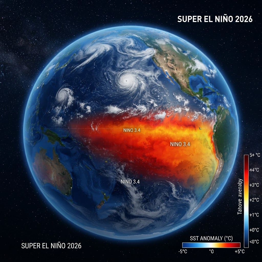
Super El Niño 2026: Why This Year's Monster Storm Season Threatens Billions
The Pacific is warming faster than scientists predicted, and the consequences are unfolding in real-time. A historic Super El Niño is intensifying across the tropical Pacific, and meteorologists warn it could shatter records for peak intensity by peak season this fall. The ripple effects—from suppressed Atlantic hurricanes to a potentially hottest year on record—will reshape weather patterns globally through 2027.
Key Takeaways
- Water temperatures in the El Niño zone are forecast to exceed 2°C above average by August–October, meeting the threshold for a historic "Super El Niño."
- Strong upper-level winds triggered by El Niño will suppress Atlantic hurricane formation this year, lowering the odds of U.S. major hurricane landfalls to just 17%—half the historical average.
- The Eastern Pacific will see enhanced tropical development, while global heatwaves, droughts in Central America and Southeast Asia, and potential flooding in East Africa loom.
- This could be the hottest year on record as El Niño stacks on top of long-term human-caused global warming.
What Is a Super El Niño, and Why Does 2026's Matter?
El Niño is one phase of a natural ocean-atmosphere cycle called the El Niño-Southern Oscillation (ENSO), which shifts tropical Pacific water temperatures up or down. When those temperatures climb at least 2°C above the long-term average for three consecutive months, meteorologists classify it as a Super El Niño—a rare, powerful event that doesn't arrive often.
According to the UN's World Meteorological Organization (WMO), strong El Niño conditions are already present and are forecast to develop rapidly from July through September, with "high confidence" in the outlook. Multiple global forecasting centers predict ocean-temperature anomalies will exceed 2°C in monitored regions by the peak months of August through October.
What makes 2026 exceptional is the speed and intensity of the current system. CNN Climate reporting notes that this El Niño "could set the new benchmark for peak intensity." Scientists are already calling it a potential "monster" event—comparable to the devastating 1997–1998 Super El Niño that triggered droughts, wildfires, and floods across six continents and caused an estimated $96 billion in global damages.
The current forecast window is narrowing. WMO spokesperson Clare Nullis told journalists that "it's the first week of July, it's the start of what is traditionally the hottest month of the year. And yet already in June we've seen record-breaking temperatures in many parts of Europe; just as an example, Germany last weekend saw a new national temperature record of 41.7°C." If late June is already shattering records, the intensity forecasts for August onward suggest even grimmer outcomes for the second half of the year.
How El Niño Reshapes the Planet's Weather Machine
The El Niño-Southern Oscillation is not some abstract climate phenomenon—it's a massive reorganization of heat distribution across the entire Pacific Basin, with tentacles reaching every inhabited continent. During normal conditions, warm water pools in the western Pacific near Indonesia and Australia, while cooler water upwells along South America's west coast. Trade winds keep this pattern locked in place.
During El Niño, those trade winds weaken dramatically, and warm water sloshes eastward across the Pacific toward the coast of Peru and Ecuador. This shift seems modest on a map, but its atmospheric consequences are planetary in scale. The warm water pumps heat and moisture into the atmosphere, altering high-altitude jet streams that steer weather systems across North America, Europe, and Asia.
For meteorologists and climate scientists, El Niño years are predictable in their chaos. Certain regions get wetter; others get drier. Hurricanes get suppressed in some basins and enhanced in others. Monsoons weaken or strengthen. The pattern has repeated itself every two to seven years for centuries, and we've learned to read its signals.
The 2026 Super El Niño amplifies these effects because the ocean-temperature anomalies are among the largest on record. A stronger heat source means stronger atmospheric perturbations, which means more extreme weather swings.
Atlantic Hurricane Season Gets a Break (But Don't Relax Yet)
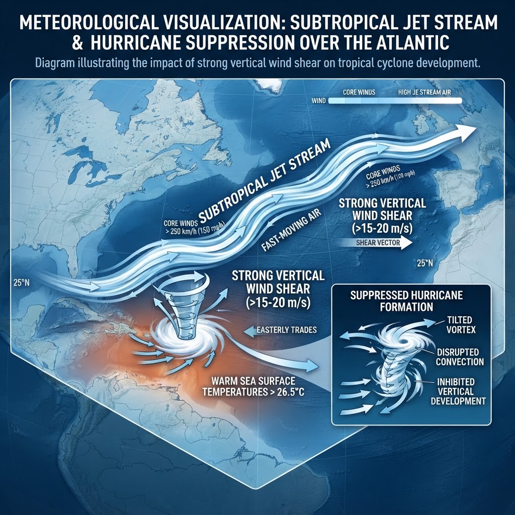
The silver lining for the U.S. Atlantic coast is that strong El Niño conditions suppress hurricane formation. The mechanism is straightforward: El Niño strengthens the subtropical jet stream over the Atlantic, cranking up upper-level wind shear. Hurricanes hate shear—it tears apart the rotating updrafts they need to develop and survive.
Colorado State University's latest forecast, issued July 8, 2026, predicts only 9 named storms, 4 hurricanes, and 1 major (Category 3+) hurricane for the 2026 Atlantic season. That's well below the 14-named-storm historical average. The probability of a major hurricane making landfall along the U.S. coast has dropped to just 17%—down from 24% in June and less than half the 43% historical average from 1880 to 2020.
Why the revised downward forecast? CSU meteorologist Phillip Klotzbach explained that the El Niño conditions are now "very likely to reach a strong El Niño (greater than 1.5°C) by the peak of Atlantic hurricane season from mid-August through mid-October." The jet stream effect intensifies as El Niño peak approaches, meaning August through October will be especially hostile for tropical development.
Yet the warning from forecasters is clear: even a "quiet" hurricane season only takes one direct hit to wreak devastation. Growing Produce reports that Tropical Storm Arthur already struck Texas in June 2026, and low-activity years can still produce singular catastrophic storms. The 1997–1998 El Niño season also featured below-average Atlantic hurricane activity overall, but was followed by the extremely active 1999 season, reminding forecasters that ENSO alone does not predict long-term Atlantic activity.
Most concerning is that reduced U.S. hurricane risk does not mean complacency is warranted. Insurance companies, FEMA, and state emergency managers will all breathe a little easier if the forecast holds, but the message remains consistent: preparation never goes out of style.
The Eastern Pacific Explodes While Asia and Africa Face Drought
What the Atlantic loses, the Eastern Pacific gains. The same warm waters that suppress storms in the Atlantic will turbocharge tropical development along Mexico and Central America's Pacific coasts. Residents of that region face increased odds of severe storms, flooding, and major hurricane threats through the fall. Eastern Pacific hurricanes also occasionally threaten the southwestern U.S. after crossing into the northeast Pacific, so even inland residents in Arizona and New Mexico may experience heavier-than-normal monsoon rains.
The Eastern Pacific has been particularly active in recent months. Forecasters have noted that the warm water anomalies there are already among the strongest on record for this time of year, suggesting that tropical development could ramp up quickly in July and August when atmospheric conditions also favor storm formation.
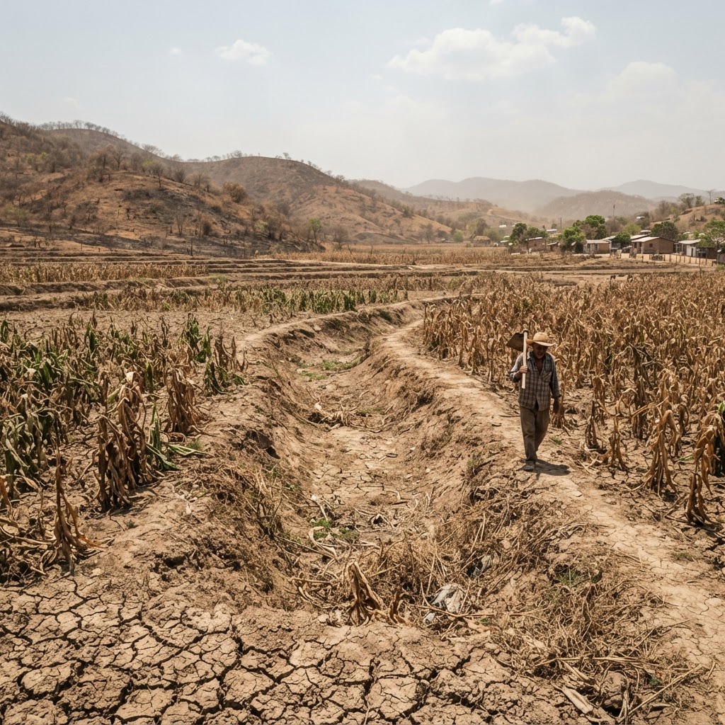
On land, the outlook is harsher. The WMO's Global Seasonal Climate Update flags "drier than average conditions" expected across Central America, the Caribbean, and parts of North and South America. Southeast Asia faces a drier monsoon season, and even parts of Indonesia will see below-average rainfall. For this region, a dry monsoon is catastrophic—these countries depend on monsoon rains to replenish water supplies and support the rice harvests that feed hundreds of millions of people.
The consequences cascade quickly: agriculture suffers, water supplies shrink, and power grids strain. For subsistence farmers in Guatemala, Honduras, Nepal, and Indonesia, a prolonged dry spell during El Niño can mean crop failure and famine. The UN World Food Programme has already flagged El Niño as a threat to food security in 2026, and harvest projections for major rice and grain-producing regions have been revised downward.
Plant-for-the-Planet's climate justice analysis stresses that extreme weather from El Niño "doesn't play fair"—vulnerable populations in the Global South bear the heaviest burden while contributing least to the carbon emissions driving the underlying warming. A farmer in Bangladesh with no savings and no insurance cannot absorb the loss of a monsoon season; a Wall Street trader with a diversified portfolio can.
One bright spot: East Africa is forecast to be wetter than normal from September through December, thanks to an interaction with the Indian Ocean Dipole (another climate driver). But this potential flooding, while breaking a drought cycle in some areas, still poses its own hazards for communities unprepared for torrential rains and mudslides. In East Africa, a swing from drought to extreme flooding can be equally devastating.
Global Temperatures Will Likely Reach Record Highs in 2026
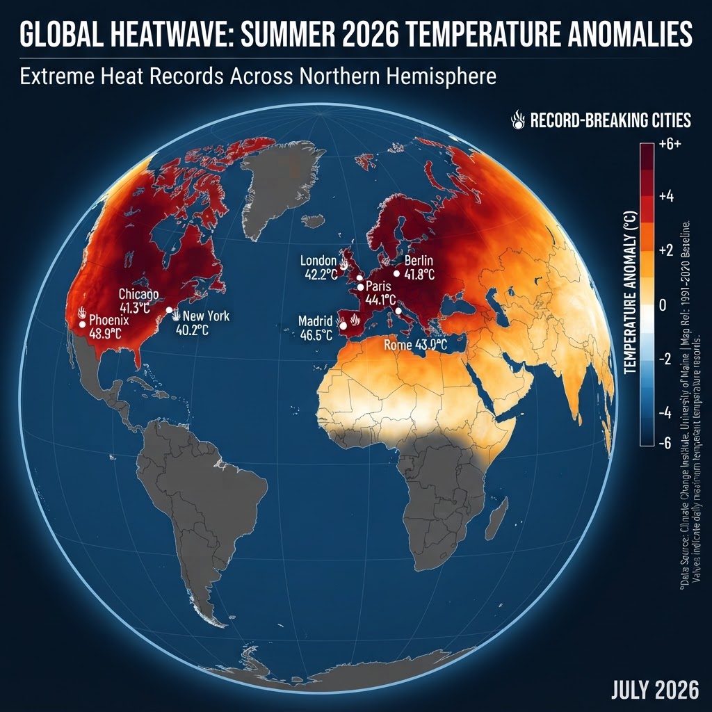
The most sobering forecast involves temperature itself. WMO scientist Alvaro Silva stated plainly: "El Niño will also give an extra boost to global temperatures. We know that during El Niño years, the global temperatures normally reach record levels."
A historic Super El Niño stacked on top of the long-term warming trend from human greenhouse gas emissions means 2026 has a high chance of becoming the hottest year on record. Even June 2026 has already seen record-breaking temperatures in parts of Europe—Germany recorded 41.7°C last weekend, a new national high. Portugal, Spain, and France also posted temperatures within a degree of their all-time records.
The heat is already baking the U.S. as well. The WMO flagged a "prolonged and dangerous heatwave" across the central and eastern United States that extended through July 4th and the Independence Day weekend. If this is only early July, the northern hemisphere's peak summer months of July and August will test power grids, strain water resources, and put vulnerable populations—the elderly, unhoused, outdoor workers—at life-threatening risk. Heat-related deaths spike during extreme heat waves; the infamous 1995 Chicago heat wave killed over 700 people in a single week, and that was before modern air conditioning was as ubiquitous.
For context, the 1997–1998 Super El Niño was associated with a global temperature spike of roughly 0.3°C above the baseline for that year. Given that the modern baseline is already 1.2°C above pre-industrial levels due to long-term climate change, a Super El Niño pushing into the summer of 2026 and peaking in early 2027 could push global averages temporarily past 1.5°C—the warming threshold that UN climate accord signatories have been trying to avoid as a tipping point for more severe climate impacts.
Why 2026's Super El Niño Could Be Even Worse Than 1997–1998
The 1997–1998 Super El Niño is the modern climate baseline for extreme ENSO events. It triggered one of the worst droughts of the century in Southeast Asia and East Africa, killed coral reefs on a massive scale, and caused crop failures across multiple continents. The total global economic toll exceeded $96 billion at the time, equivalent to over $180 billion in 2026 dollars.
The 2026 Super El Niño is developing into the strongest event since 1997–1998. The current ocean-temperature anomalies are already among the highest on record for early July. If the forecast peak of 2°C+ anomalies holds, 2026 could match or exceed the 1998 record. Unlike 1998, however, the baseline global temperature is 0.8°C warmer due to long-term climate change. That means the same El Niño-driven spike will occur on top of a world already running hotter than in the 1990s, amplifying the severity of heat waves, droughts, and other extremes.
In practical terms, a region that experienced record heat in 1998 might experience heat so extreme in 2026 that existing infrastructure—power plants, hospitals, water treatment facilities—simply cannot cope with the demand. The death toll and economic losses from a comparable-intensity El Niño today could dwarf the 1997–1998 impacts.
What Happens Next? A Race Against Time for Preparedness
WMO's Alvaro Silva issued an urgent call: "We have a window to act for preparedness for early action. And this window is narrowing in some regions."
For governments in drought-prone zones, action means securing water for agriculture, energy production, and drinking supplies before dry conditions peak. Hydroelectric facilities in Central and South America will face lower reservoir levels; countries dependent on hydropower for electricity could face rolling blackouts. For island nations facing the risk of torrential rains and storm surge, it means reinforcing infrastructure and evacuation plans. For wealthy nations expecting fewer hurricanes, it means resisting the temptation to complacency—even a single major storm could inflict billion-dollar damages.
The 2026 Super El Niño is not a surprise anymore; it was forecast months ago. But the speed and intensity of its development suggest the impacts could surpass even conservative predictions. This is one of those rare climate events where preparation, funding, and international coordination can genuinely save lives. The question now is whether the world will mobilize in time.
For more on how extreme weather systems reshape our climate, read our deep-dive on record heat waves striking 30 countries simultaneously.
FAQ: Super El Niño 2026
How long will the 2026 Super El Niño last?
El Niño events typically last between nine and 12 months. This one is expected to strengthen from July through September and peak between November and February 2027. Its influence on global temperatures will be strongest in the 12 months following its onset.
Will this Super El Niño cause stronger hurricanes in the Atlantic?
No—the opposite. El Niño increases upper-level wind shear in the Atlantic, which suppresses hurricane formation. The 2026 Atlantic hurricane season is forecast to be one of the least active in over a decade. However, a strengthened Eastern Pacific means more storms on the other side of North America, particularly Mexico and Central America's Pacific coasts.
Which regions will suffer the most drought during this El Niño?
Central America, the Caribbean, parts of North and South America, Southeast Asia, and Indonesia are all forecast to see drier-than-average conditions. East Africa is an exception—it is expected to be wetter than normal from September onward, though flooding carries its own hazards for unprepared communities.
Could 2026 become the hottest year on record?
Yes. The combination of a historic Super El Niño and ongoing human-caused global warming makes 2026 a strong candidate for the hottest year in the modern temperature record. June 2026 already saw record-breaking heat across Europe and North America, and El Niño-driven temperature spikes could push global averages past 1.5°C above pre-industrial levels.


Comments
Post a Comment